

HIGH ROUTE OF THE LOST
Classic + Monte Perdido + Vignemale
-
 8 stages
-
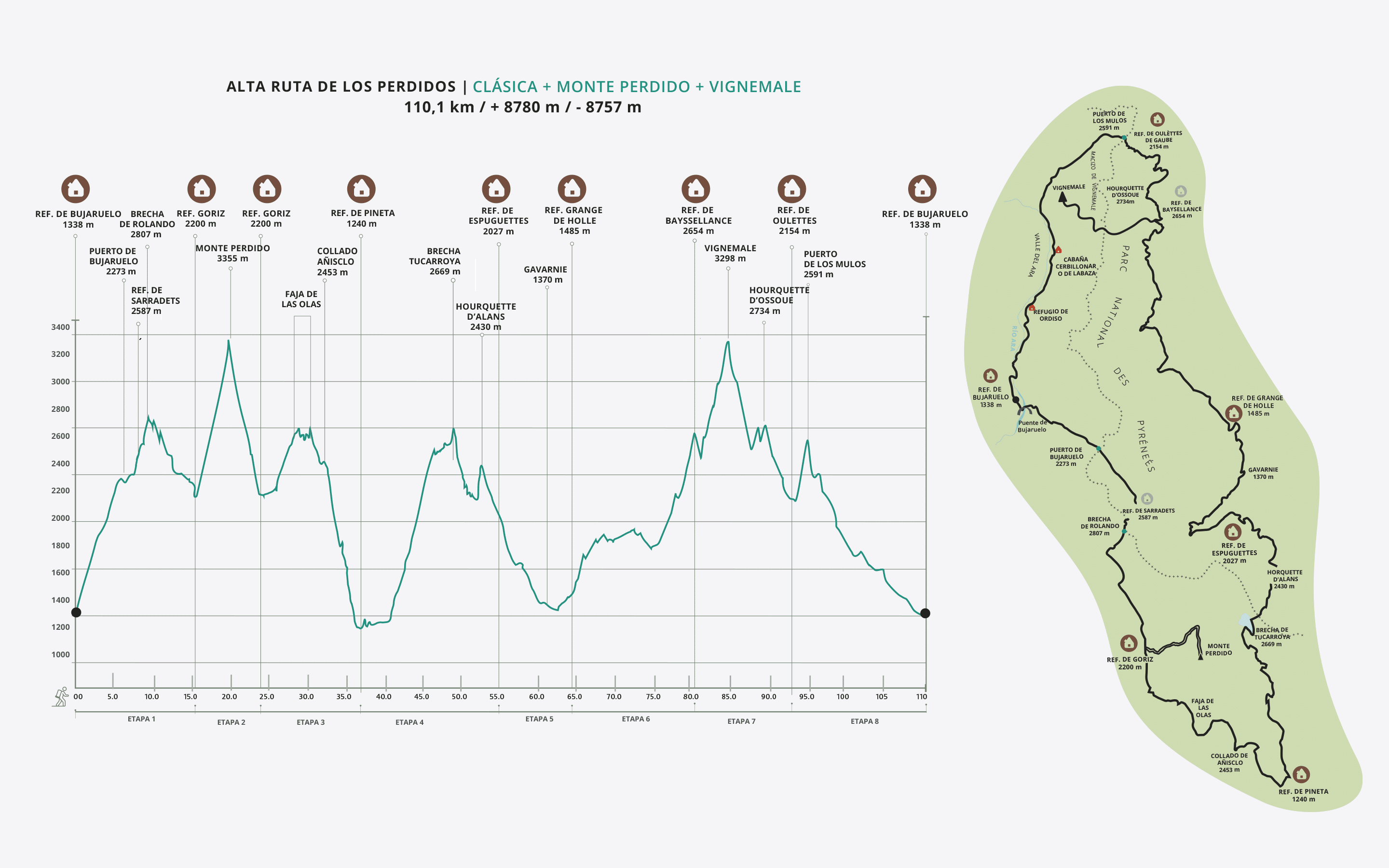
 110.1 km
-
 +8,780 m/-8,780 m
-
 Physical Difficulty: High
-
Technical Difficulty: High
The ultimate challenge: the most ambitious circular route in the Central Pyrenees, linking two legendary peaks in a single epic journey. The Alta Ruta de los Perdidos (High Route of the Lost) crowns the two stone giants that dominate the horizon: Monte Perdido and Gran Vignemale.
As of
689,00 €
HIGH ROUTE OF THE LOST
Classic + Monte Perdido + Vignemale
-
8 stages
-
110.1 km
-
+8,780 m/-8,780 m
-
Physical Difficulty: High
-
Technical Difficulty: High
LIVE THE MYTH
THE ROUTE
DAY 1
Place of origin: Bujaruelo Refuge
From the Refugio de Bujaruelo to the Refugio de Góriz.
From Bujaruelo we cross the Roman bridge and ascend following the red and white marks that indicate the passage of the GR 11 to the Puerto de Bujaruelo. Here we follow the sign that leads us to the Brecha de Rolando Refuge. From the same Gap we will continue first a little to the right by some blocks to begin the descent along a path marked by milestones that will take us to the Narciso Flats. From here we turn to our left (NE direction) and reach the pass of Millares to continue along the plains of the same name without difficulty to the ref. of Góriz.
DAY 2 / STAGE 1
La Brecha and the Ordesa Canyon
-
15.9 Km
-
+1626m/-761m
From the Refugio de Bujaruelo to the Refugio de Góriz.
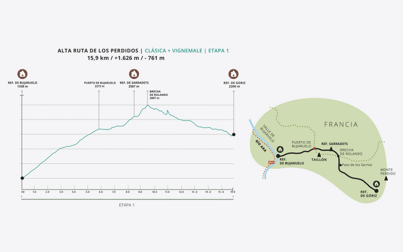
From Bujaruelo we cross the Roman bridge and ascend following the red and white marks that indicate the passage of the GR 11 to the Puerto de Bujaruelo. Here we follow the sign that leads us to the Rolando Gap Refuge. Once in the Brecha we descend towards the Collado del Descargador through the Paso de los Sarrios. Here we will find the first technical step of the route with chains that help us in its progression. There is an alternative path from the Brecha itself to avoid this pass. From the Collado del Descargador we will continue towards the plain to access the Refugio de Góriz.
DAY 3 / STAGE 2
Ascent of Monte Perdido from Góriz
-
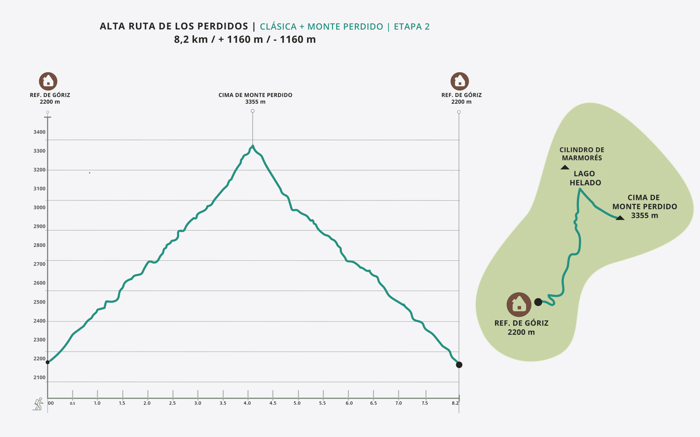
8.2 km
-
+1,160 m/-1,160 m
Monte Perdido from the Góriz Refuge
The ascent to Monte Perdido (3,348 m), one of the most emblematic three-thousanders in the Pyrenees and the highest point in the Ordesa massif, starts from the Góriz Refuge.
The well-marked trail heads north, gradually gaining altitude. As you ascend, the terrain changes from a trail to areas of rocky outcrops and scree, marked with cairns.
The route continues to Lago Helado, a common spot for assessing conditions before tackling the final stretch. From here, you reach La Escupidera, a steep, exposed slope that leads to the summit. In summer and in good weather, it does not present any extreme technical difficulty, although it does require attention and experience in high mountains.
From the summit, the views of the massif, its mountain lakes, and its glacial valleys amply reward the effort. The descent follows the same route as the ascent.
It is common to find snow until mid-July, making it essential to use crampons and ice axes, as well as knowing how to use them correctly.
DAY 4 / STAGE 3
Collado de Añisclo and Pineta Valley
-
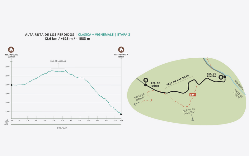
12.6 Km
-
+625m/-1583m
From the Góriz Refuge to the Pineta Refuge.
We leave Góriz following the GR 11 marks that go up little by little to the Collado Superior de Góriz. At this point we leave the GR 11 that descends to the Añisclo Canyon and take the milestones in a northeasterly direction that lead us through the Faja de las Olas to the Collado de Añisclo, where we also find an area of chains that help us in our progression. To avoid this technical step we can descend to the Fuen Blanca, and then ascend to the Collado de Añisclo. We carefully descend the long and demanding descent from the Collado de Añisclo to the Pineta Refuge.
DAY 5 / STAGE 4
The Monte Perdido Glacier
-
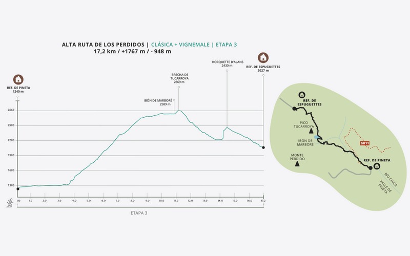
17.2 Km
-
+1767m/-948m
From Pineta Refuge to Espuguettes Refuge.
From Pineta we follow the National Park signs to the Balcón de Pineta and Lago de Marboré. We continue bordering the lake on the right towards the Brecha and Refugio de Tucarroya. We climb to the gap and from here we descend a steeply sloping channel with many loose rocks that requires us to go down with caution. In case of snow, the difficulty increases and it is essential to use ice axes and crampons. There is also an alternative variant through the Puerto Nuevo de Pineta that avoids this technical step. Once we descend from the Brecha de Tucarroya we head towards the Horquette d'Alans by an uphill path. Descent to the Espuguettes Refuge where we will enjoy unbeatable views.
DAY 6 / STAGE 5
The Cirque de Gavarnie
-
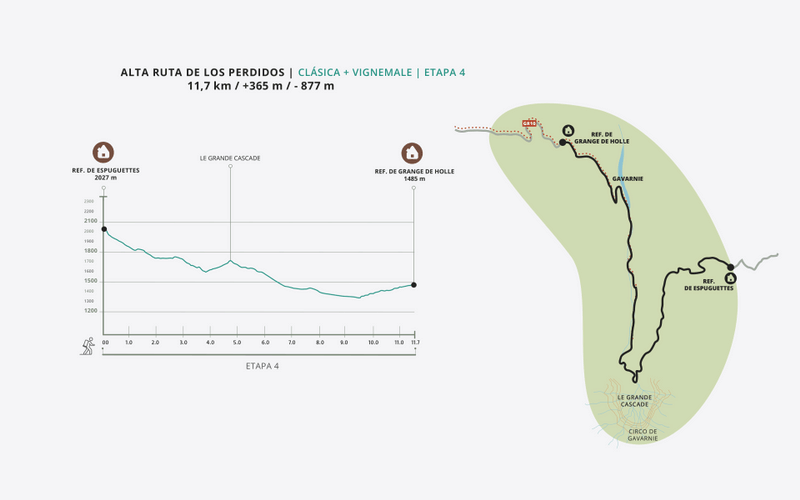
11.7 Km
-
+385m/-877m
From the Espuguettes Hut to the Grange de Holle Hut.
Departure from the Espuguettes Refuge towards Gavarnie. After a steep descent we will find a sign indicating the path to the Cirque de Gavarnie to the left. We walk along this beautiful forest path that will leave us at the base of the imposing Cirque de Gavarnie. From the Hotellerie du Cirque to Gavarnie is a walk of about an hour. From the village of Gavarnie to the Grange de Holle refuge there is a path that is not easy to find. Follow the signs to the cemetery and after the cemetery take an unmarked path to the right that will lead you to the Grange de Holle refuge.
DAY 7 / STAGE 6
The Great Vignemale
-
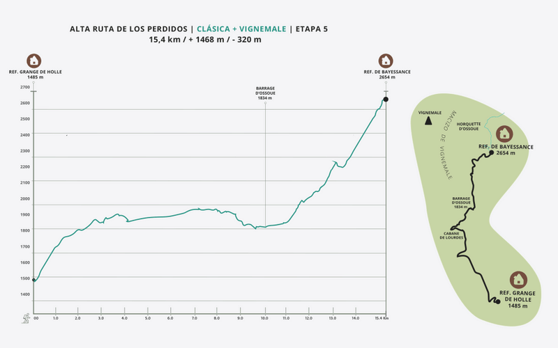
15.4 Km
-
+1468/-320m
From the Grange de Holle Refuge to the Baysellance Refuge.
The exit from the Grange de Holle refuge is a little confusing, so it's best to ask the guard. We head along a forest path to the Ossoue Valley. We pass in front of the Lourdes Hut, cross the Ossoue Dam, and take the climb that will take us to the Bayssellance Refuge.
DAY 8 / STAGE 7
Ascent to Vignemale and Oulèttes de Gaube
-
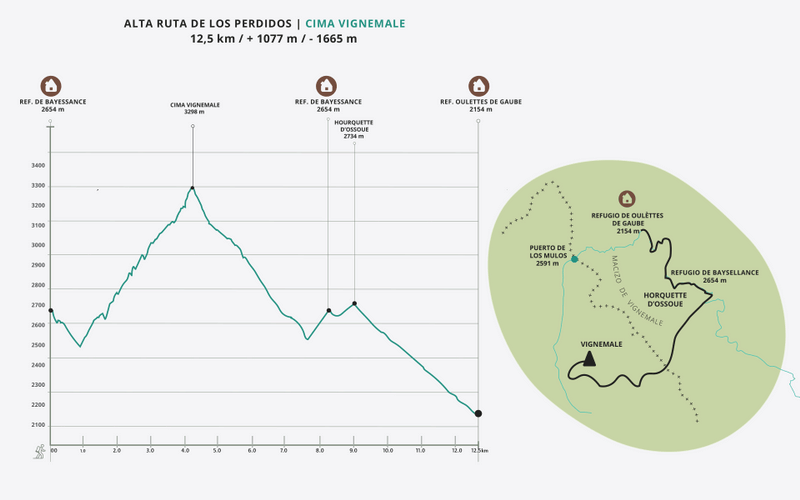
12.5 Km
-
+1077/-1665m
Ascent of Vignemale from the Bayssellance Refuge to the Oulèttes de Gaube Refuge.
We leave the Bayssellance refuge (2,654 m) and descend a few meters along the GR 10 towards the Ossoue dam. Shortly after, we leave this trail on the right (once we have passed the Petit Vignemale ridge) and take a fairly well-marked trail that begins the ascent to the glacier towards the west.
We follow the trail, which is clear at the beginning but becomes less so shortly after, only to become clearer again further on. We have to traverse the less marked section, using our hands for support at times and paying attention to possible slips and falling rocks from the ridge and walls of the Petit Vignemale. It is not a difficult section, but we must be careful (we can avoid this section by descending the GR 10 to the bend that leads to the Grottes Bellevue, and then turning off from there towards the glacier). This alternative involves less objective risk but increases the elevation gain of the activity.
We climb up the moraine that leads us to the Ossoue glacier, until we reach the summit pyramid of the Pique Longue. From there, we begin a simple but long climb (about 150 m) over broken terrain. The steepness of the terrain and the risk of falling rocks make this last section before the summit somewhat exposed. We ascend to the summit following a multitude of landmarks that mark different routes. All are of similar difficulty and converge at the summit of Pique Longue (3,299 m), the highest peak in the Vignemale Massif.
We descend via the same route.
This ascent takes place in high mountain terrain and crosses a glacier with crevasses, making technical knowledge of snow and ice progression essential. Ice axes, crampons, and helmets must be used, and roping up should also be considered.
We descend by the same route returning to the refuge of Bayssellance. We continue along the path that goes up to the Horquette d'Ossoue and descends to the refuge of Oulèttes.
DAY 9 / STAGE 8
The reward
-
16.6 Km
-
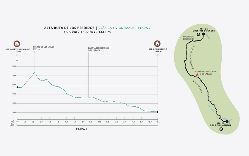
+592/-1443m
From Oulèttes de Gaube hut to Bujaruelo hut.
Departure from Oulèttes towards the Col des Mules. Descent from the pass following the red and white markings of the HRP. Marks that we leave to go to the Ara Valley that after a long and smooth descent will lead us back to the Roman Bridge of Bujaruelo and the refuge.
HIGH ROUTE OF THE LOST
REFUGIOS
REFUGIOS
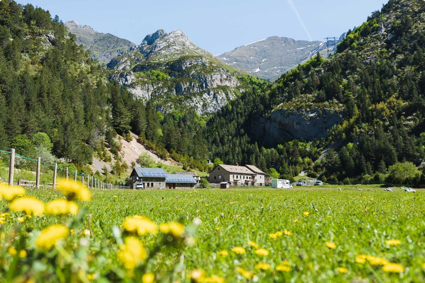
Bujaruelo Refuge
Guards: José Luis, Rafa and Esther
Rooms: 2, 4, 8 and 20 seats.
Necessary: Saco or sheet
Includes: Comforters
Bathroom: With hot water shower
Breakfast: From 7am
Dinner: From 8:30 pm
Extra services: Pic-nic and cafeteria (7h - 22h).
REFUGIOS
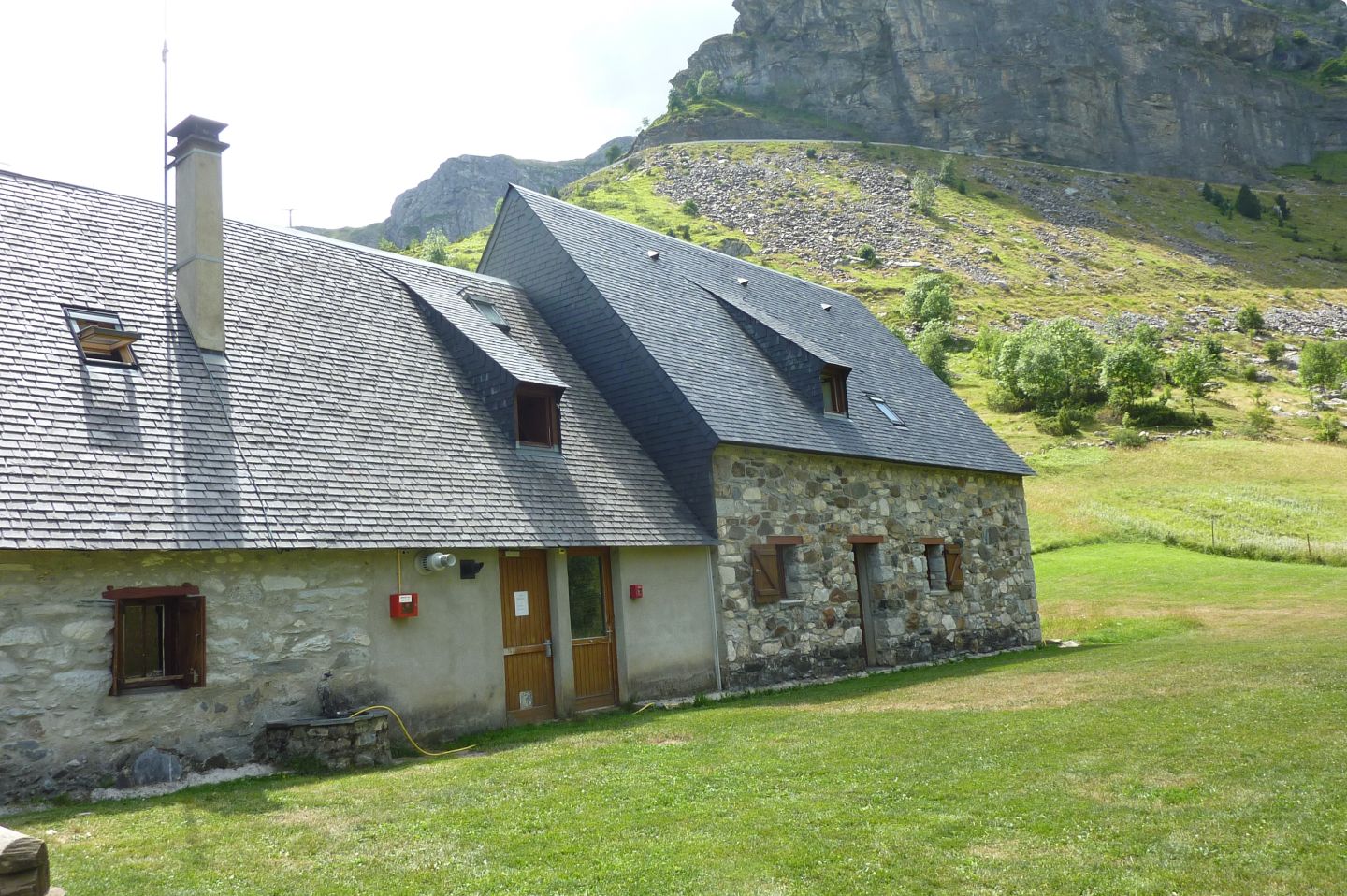
Refuge La Grange de Holle
Guards: Amelie and Philippe
Rooms: Communal
Includes: Blankets
Bathroom: With hot water shower
Dinner: Shifts at 19h in summer.
Extra services: Pic-nic and bar
ENJOY TO THE FULLEST
ADDITIONAL INFORMATION
Includes
All of this is included in your adventure:
Total Safety: Garmin device with geolocation and satellite technology. Includes constant professional monitoring by our team. Guaranteed communication with us even without cell service and an SOS button that immediately activates the rescue protocol.
Comfort: Half board at all shelters + Picnics at the Bujaruelo Shelter and in Góriz).
Management: Registration and full reservation of guaranteed places.
Material: Official map of the Alpina route, official T-shirt, and passport for stamping at mountain huts.
Experience: Technical briefing in Bujaruelo, welcome drink at each refuge, and final toast.
Does not include
1. Transfers to/from Bujaruelo (ask us if you need transportation).
2. Personal expenses and tips.
3. Expenses derived from unexpected events, either by third parties or meteorological events (delays, cancellations, floods, landslides, snowfalls, natural disasters, etc.). New: you can take out the flexible cancellation insurance to cover these situations.
4. Any service not specified in the "Included" section.
Rates for 2026
Non-member: €737
Member (*): €689
(*) The federated price includes both FEDME and hut correspondence.

Extra Services
Guided climb up Vignemale: Add a guided climb to your trip, focusing exclusively on the summit day up Vignemale. A unique opportunity to safely reach this legendary peak during your route; check availability and prices.
Accident insurance for the whole trip: 30 € per person consult conditions here.
Early cancellation insurance: 50 € per person check conditions here.
Flexible cancellation insurance: 99€ see conditions here.
Rental of Petlz ice axes and crampons: pack (6€ per day) / 1 tool (3€ per day).
Exclusive Ternua T-shirt: 18€

MORE THAN AN EXPERIENCE
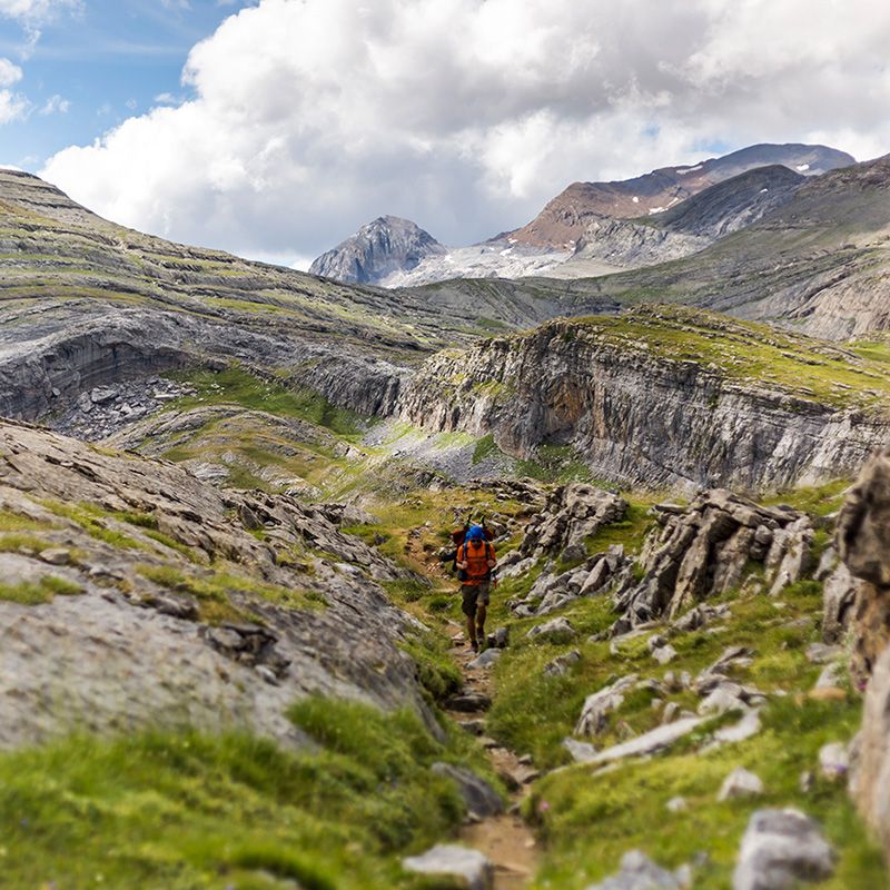
More than just walking, you embark on a unique experience that begins long before you take your first step on the mountain.

Safety at every step
You will feel safe thanks to the latest technology in real-time monitoring, which allows us to intervene quickly if something does not go according to plan.

LEARNING AT EVERY STEP
Learn and evolve as a mountaineer with the videos and trainings we offer you, improving your skills to enjoy every mountain adventure to the fullest.