

Waters of Aneto
The Classic
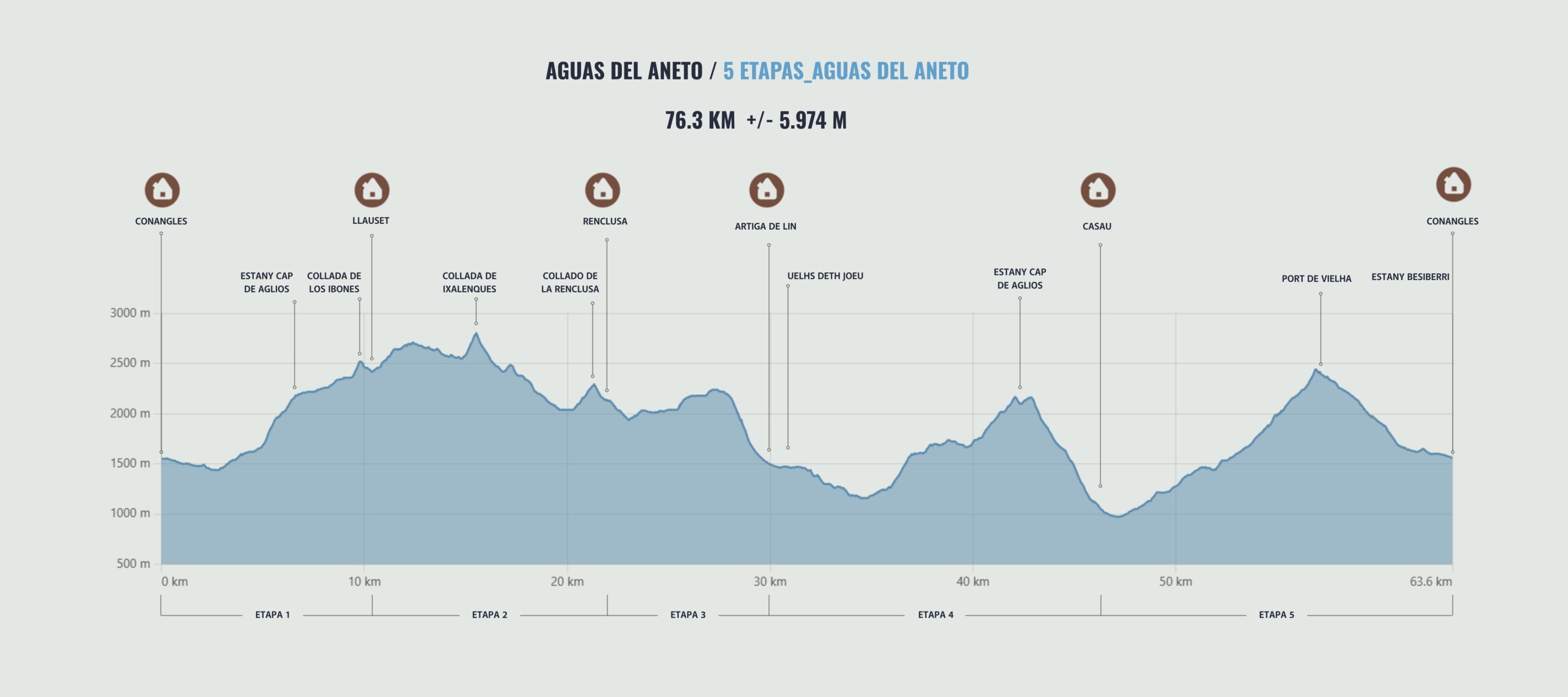
Master the eternal water cycle on this 5-stage journey through the Kingdom of Aneto. Follow the circular route that connects the history of La Renclusa with the modernity of Llauset, overcoming more than 5,000 meters of elevation gain. You will accompany the water from its disappearance in Forau de Aigualluts to its reappearance in the Aran Valley, conquering legendary passes such as Collado de Salenques (2,809 m). A challenge of endurance and technique designed for those seeking maximum authenticity and a complete map of the heart of Maladeta.
As of
525,00 €
WATERS OF ANETO
THE CLASSIC
-
 5 stages
-
 76.3 km
-
 +5,974 m/-5,974 m
-
 Physical Difficulty: High
-
Technical Difficulty: High
FOLLOW THE TRAIL
THE ROUTE
DAY 1
Place of origin: Conangles Refuge
Arrival at the Conangles Refuge, where we will welcome you, introduce ourselves, and give a brief orientation talk about the high mountain crossing.
At this meeting point, we will give you your welcome pack, review the details of the route and the mountain conditions, and show you how to use the safety geolocation device that will be at your disposal throughout the tour. Here you can ask any last-minute questions and finish preparing your mountain equipment before beginning this adventure in the Pyrenees.
DAY 2/ STAGE 1
From the Conangles Refuge to the Cap de Llauset Refuge.
The route begins by ascending the valley in search of the Anglos lake basin. The trail progresses between mountain lakes and granite scree, steadily gaining altitude until it reaches the Coll de los Estanyets (2,524 m). From this point, a short descent takes us to the Cap de Llauset Refuge, the most modern in the Pyrenees, located in a purely mineral high mountain environment.
DAY 3/ STAGE 2
The balcony of the route, the Salenques Pass
A technical high-mountain route that circles the massif on its eastern side. The route climbs to Collado de Salenques (2,809 m), the highest point of the crossing and a privileged viewpoint of the Aneto Glacier. The descent is via Val de Salenques, a demanding terrain of boulders and loose rock that requires caution, finally climbing back up to the historic Refugio de la Renclusa.
DAY 4 / STAGE 3
The Mystery of Aigualluts and Coll de Toro
From Renclusa, we descend towards Plan de Aigualluts to witness the greatest mystery of the route: Forau de Aigualluts, where the waters of the glacier sink into a karst sinkhole. We then begin the technical ascent to Coll de Toro (2,237 m), the natural border with the Aran Valley. After reaching the top of the pass, the route descends sharply towards the Artiga de Lin basin, a breathtakingly vertical environment surrounded by glacial cirques where we will spend the night.
DAY 5 / STAGE 4
From the Artiga de Lin Refuge to Casau (Vielha)
We begin the day descending through the Artiga forest until we reach Uelhs deth Joèu, the exact point where the waters we saw disappear in Aigualluts reappear with thunderous force after a 4 km underground journey. After visiting this landmark, the route continues halfway up the hillside along paths with lush Atlantic vegetation, gently gaining height to flank the mountain until reaching the village of Casau, a privileged balcony overlooking the Aranese capital.
DAY 6 / STAGE 5
The Garonne River Basin
Last day of the journey to close the circular circuit. The itinerary goes up the valley looking for the connection back to the south entrance of the Vielha tunnel. We will cross areas of high grassland and ancient shepherds' paths, arriving at the Vielha Pass where we can say goodbye with the last spectacular views of the Aneto massif, before descending directly to the Conangles Refuge, the final point of the expedition, thus completing the cycle of water and rock.
WATERS OF ANETO
ADDITIONAL INFORMATION
Includes
All of this is included in your adventure:
Total Safety: Garmin device with geolocation and satellite technology. Includes constant professional monitoring by our team. Guaranteed communication with us even without cell service and an SOS button that immediately activates the rescue protocol.
Comfort: Half board in all shelters
Management: Registration and full reservation of guaranteed places.
Material: Official map of the Alpina route, official T-shirt, and passport for stamping at mountain huts.
Experience: Technical briefing, welcome drink at each shelter, and final toast.
Does not include
1. Transfers to/from Conagnes (contact us if you need transportation).
2. Personal expenses and tips.
3. Expenses arising from unexpected events, whether caused by third parties or weather conditions (delays, cancellations, floods, landslides, snowfall, natural disasters, etc.). New: you can take out flexible cancellation insurance to cover these situations.
4. Any service not specified in the "Includes" section.
Rates for 2026
Non-member: €551
Member (*): €525
(*) The federated price includes both FEDME and hut correspondence.

Extra Services
Accident insurance for the whole trip: 30 € per person consult conditions here.
Early cancellation insurance: 50 € per person check conditions here.
Flexible cancellation insurance: 99€ see conditions here.
Rental of Petlz ice axes and crampons: pack (6€ per day) / 1 tool (3€ per day).
Exclusive Ternua T-shirt: 18€

MORE THAN AN EXPERIENCE
More than just walking, you embark on a unique experience that begins long before you take your first step on the mountain.

Safety at every step
You will feel safe thanks to the latest technology in real-time monitoring, which allows us to intervene quickly if something does not go according to plan.

LEARNING AT EVERY STEP
Learn and evolve as a mountaineer with the videos and trainings we offer you, improving your skills to enjoy every mountain adventure to the fullest.